11.3.1.1
ESUs must be drawn along the centre of the part of the Street which carries the highest public rights.
11.3.1.2
An ESU starts or ends in one of the following places:
- The start or end of a Street.
- A Street junction (same or different Street, including at named roundabouts).
- The end of the publicly maintainable highway.
- At the limits of Network Rail’s responsibility at a Level Crossing.
- A change in the characteristics of the Street, for example:
- Access restriction (for example no-entry, gate access).
- Change from single to dual carriageway.
- Change of HIGHWAY_DEDICATION_CODE. (See Section 9.4).
11.3.1.3
In rural areas it can be appropriate to split ESUs at the edge of settlement (that is, the urban/rural split) if it is clearly delineated for example, by a speed limit change. This does not mean it is always necessary to split at a change of speed limit.
11.3.1.4
The following must be separate ESUs:
- Separate carriageways of dual carriageways.
- Link and slip roads, for example at complex junctions.
- Links in a named roundabout.
11.3.1.5
ESUs must end at features that exist in the real world, for example a junction. If it is necessary to break a long Street in a remote rural area, this can be one of the following:
- A stream.
- A bridge.
- A boundary marker.
11.3.1.6
For Private Streets, ESUs must not be split at changes between two or more private owners, except where other criteria requiring splitting also apply.
11.3.1.7
The ESU ID must also be cross-referenced to the USRN for which it was originally created (unless it is moved to new Street), even if the geometry of the USRN or ESU changes. If an ESU is currently not referenced by a live USRN it must be closed.
11.3.1.8
For details of the special conditions for the creation and maintenance of Motorway ESUs, see Section 7.
11.3.1.9
ESU IDs must be constructed from the easting and northing at the mid-point of the ESU. These coordinates must be left padded with zeroes to 7 characters before they are combined. The leading zeroes of the easting disappears when the ESU ID is converted to an integer, for example, an ESU with a centre of 123456, 234567 has an ESU ID of 1234560234567. Ensure that a cross-over point is not used as an ESU ID if Streets cross without meeting, for example, a bridge, an underpass or a multi-level walkway.
11.3.1.10
The ESU ID must not change, even if the geometry of the ESU is changed at a later date.
11.3.1.11
Sometimes, ESU IDs are the same in more than one LSG. When many LSGs are combined into the NSG, the ESU ID must be considered with the SWA_ORG_REF_NAMING code (LAID) of the SNN Authority to ensure a nationally unique and persistent identifier is used.
11.3.1.12
Apply the following rules to the date Fields within the type 13 ESU Record:
- RECORD_ENTRY_DATE
- The date that the Record is recorded in the LSG. This does not have to be the same as the ESU_START_DATE because of latency in Record entry that is, when the ESU is recorded it does not always already exist in the real world.
- LAST_UPDATE_DATE
- The date on which any attribute of the Record was changed. This must be date that any alteration was made to the type 13 Record. Sometimes, more than one alteration is made between submission periods. The date of DCA Street Update transfer file to GeoPlace must be the date of the last change.
- ESU_START_DATE
- The date on which the ESU starts to exist in the real world. This can be a date before the RECORD_ENTRY_DATE, because of latency in data entry. This can also be after the RECORD_ENTRY_DATE because sometimes Street Data is required for operational use before the Street exists on the ground.
- ESU_END_DATE
- The date on which the ESU ceases to exist in the real world or was replaced by one or more new ESUs. This is also the Record’s end date.
11.3.1.13
Figure 34 to Figure 39 show where node linkages must be in the carriageway, particularly at T junctions, cross roads and roundabouts.
11.3.1.14
Figure 34 to Figure 37 show ESU node connectivity at a variety of junctions and Street ends. The ESU extremity points must be as close to the centre of the road as possible. All ESU extremity points must snap to the adjacent ESU.
Figure 34 - Junction node linkage:
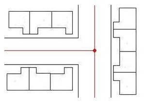
Figure 35 - Crossroad node linkage:
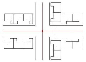
Figure 36 - Shaped Street node linkage:
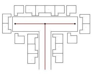
Figure 37 - Staggered junction node linkage:
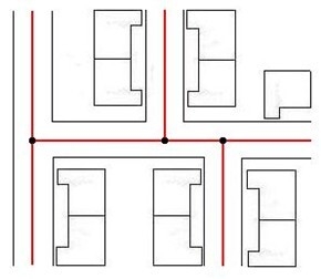
Figure 38 - Roundabout example 1:
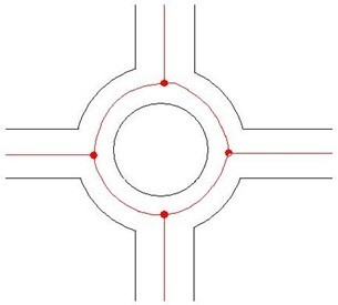
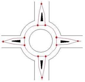
Figure 39 - Roundabout example 2:
11.3.1.15
Named roundabouts must be recorded into an LSG as type 1 Streets. Each exit to exit section of a roundabout must be recorded as a separate ESU cross-referenced to the appropriate USRN. For an example, see Figure 38 and Figure 39.
11.3.1.16
If a roundabout is not officially named, the ESUs must be attached to the appropriate type 1 or 2 Street, from or to the roundabout. The ESUs for the roundabout are usually attached to the primary Street (that is the Street with the highest classification or the main Street).
11.3.1.17
If there is no main Street, then the ESUs can be divided between all or some of the Streets serving the roundabout. In ambiguous cases such as this, a methodical and consistent approach should be taken that meets the operational needs of the DCA Participating Authority.
11.3.1.18
Mini Roundabouts must not be recorded as separate Streets.
11.3.1.19
If a Mini Roundabout forms the junction between Streets, then the ESUs must meet in the centre of the Mini Roundabout.