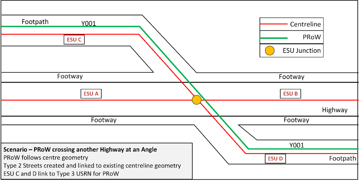
18.4.1 PROWs crossing the Highway at an angle.
Where a PRoW (green line) crosses another Highway at an angle, as in Figure 42, then the centrelines are drawn for both and they intersect in the centre of the other Highway, as shown.
Figure 42 - PRoW crossing another Highway at an angle
18.4.2 PROW is in the margins of a Highway.
- Where a PRoW is in the margins of a Highway of which it is part, for example in the verge, Footway or Cycle Way, then a separate centreline for the PRoW must not be created. In theory, such a PRoW should not be on the Definitive Map, but in practice there was not a legal order to remove it from the Definitive Map, or it was diverted into the margin of the Highway rather than deleted. The type 67 ASD Coordinate Record must reflect the true position of the PRoW. Figure 43 shows examples of this below.
Figure 43 - Two examples of a PRoW (green line) on a Footway within the margins of a Highway
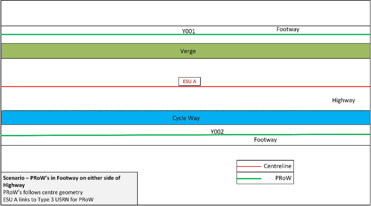
These are recorded as follows:
Table 24 – Fields and records for PRoWs on a Footway
Centreline ESUs
Yes
No
Street STATE code
2
N/A
HIGHWAY_DEDICATION_CODE
8
As recorded on Definitive Map as either 2, 4, 9 or 10
HD_PROW
Yes
N/A
PRoW Record
No
Yes
ASD Coordinate Record
No
Yes
Type 3 Street
If a Classified Road
Yes mandatory
18.4.3 PRoW running parallel to another Highway
- However, where a PRoW runs parallel to another Highway but is separated from it by an impassable or physical barrier (other than a safety barrier) then it must be recorded with a separate ESU. See Figure 44.
Figure 44 - Example of PRoW (green line) running parallel to another Highway of which it is not a part
These are recorded as follows:
Centreline ESUs
Yes
Yes
Street STATE code
2
2
HIGHWAY_DEDICATION_CODE
8
As recorded on Definitive Map as either 2, 4, 9 or 10
HD_PROW
No
Yes
PRoW Record
No
Yes
ASD Coordinate Record
No
Yes
Type 3 Street
If a Classified Road
Yes mandatory
Table 25 – Fields and records for PRoWs that are parallel to another Highway
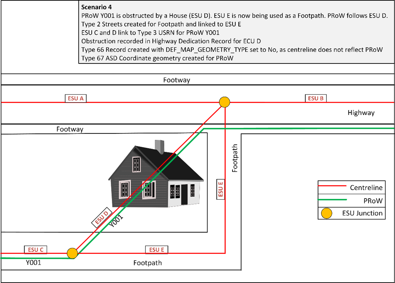
18.4.4 Dealing with obstructions
- Where a PRoW is physically obstructed, there may be an alternative route provided. Examples of this are:
- a house was built on a PRoW and another path provided around it, but the PRoW has not been diverted.
- a PRoW along a river bank or cliff was eroded and a different route must be identified by the landowner/Local Highway Authority.
Both routes need to be present in the NSG.
Note: The intention here is not to record a diversion that is a simple trespass, but the situation where a genuine alternative path was provided by the developer, but the public rights have not been altered to reflect this situation.
In Figure 45, the PRoW running directly from ESU C, D to B was obstructed by a house built upon it. A new path was provided via ESU E which is not a PRoW. Both Streets can have the same USRN but must have separate ESUs, alternatively if the descriptions are fundamentally different, a separate USRN can be used for ESU E.
The two routes are recorded as follows:
Table 26 – Fields and records for PRoWs that have an obstruction
Centreline ESUs
Yes
Yes
Street STATE code
2
HIGHWAY_DEDICATION_CODE
As recorded on Definitive Map as either 2, 4, 9 or 10
4
HD_OBSTRUCTION
Yes
No
HD_PROW
Yes
No
PRoW Record
Yes (Optional)
No
ASD Coordinate Record
Yes (if the definitive geometry for ESU B is required)
No
Type 3 Street
Yes mandatory
No
Figure 45 - Obstruction on PRoW