8.3.1.1
All ESUs that are a PRoW must be flagged as such in the type 17 Highway Dedication Record. This means the type 17 Highway Dedication Record PRoW indicator Field – HD_PROW, must be set to “1”, see Section 9.4.6. A type 66 PRoW Record can also be added.
8.3.1.2
All PRoW routes must be captured and be based upon a centreline network meaning they must extend to the existing centreline. This, in some cases, is not an exact representation of the PRoW Definitive Map network but provides a realisation of it linked directly to the existing Street network.
8.3.1.3
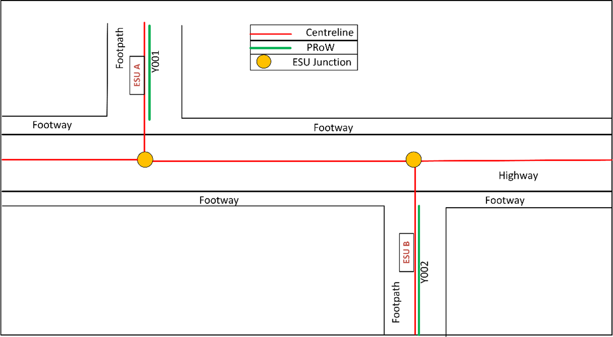
An example is, stopping at the edge of another Highway, but connected to the centreline of the Street. If an exact representation of the Definitive Map network is required then the type 66 PRoW Record and type 67 ASD Coordinates must be recorded, as defined in Figure 22 below.
Figure 22 – Relationship of ESU network to PRoW routes
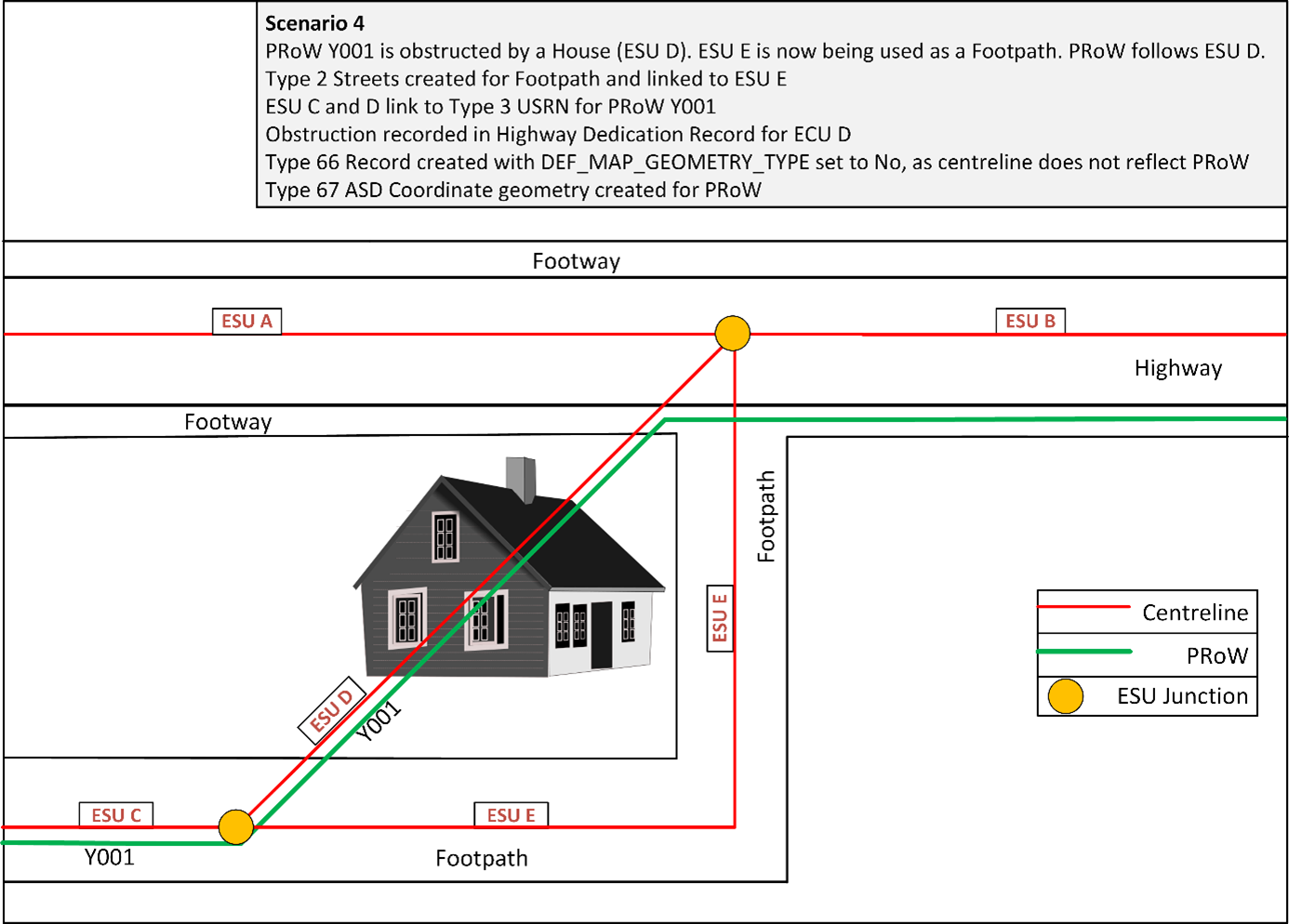
8.3.1.4
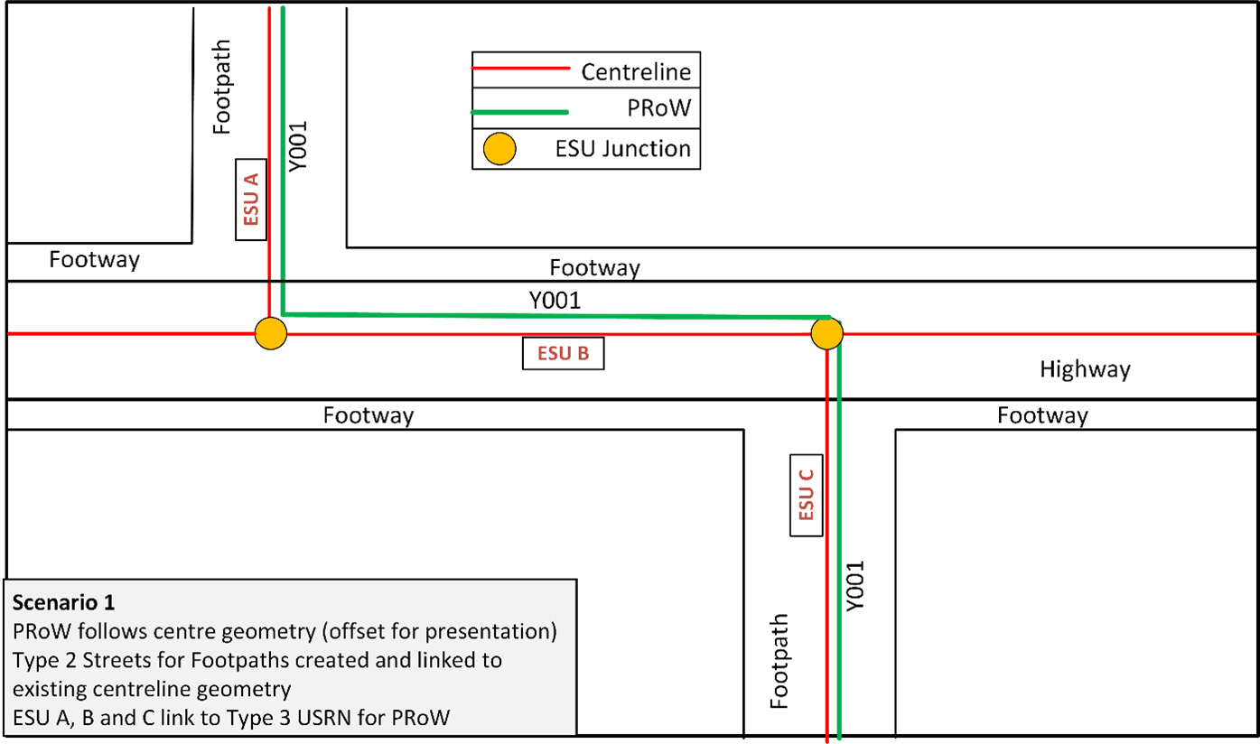
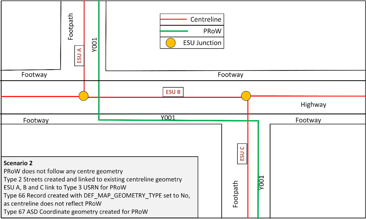
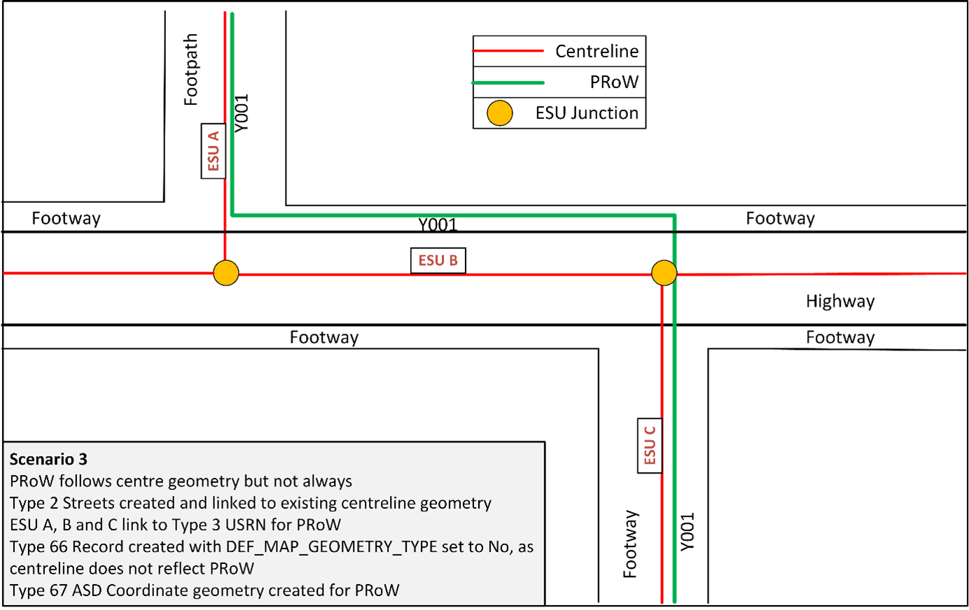
Figure 23 below represents three common scenarios (Scenarios 1 -3) where the PRoW on a Highway – open to all vehicles, is as defined on the Definitive Map. In these instances both the ESU network and PRoW (Definitive Map) are identified on the footpath and footways of a Street. Additionally, Scenario 4 identifies where a PRoW is obstructed by the construction of a house.
ESU geometry
- The ESU geometry created must be captured and be based upon a centreline network. All networks must join the ESU network and be an extension of it.
Type 3 network
- The type 3 network should cross reference all ESUs relevant to the PRoW, at this point it may not be a definitive representation of the PRoW.
Definitive PRoW
- For LHAs wishing to record PRoW as per the Definitive Map and statement the red PRoW in this example can be recorded via the type 66 PRoW Record which is linked to the type 3 Street USRN created and the type 67 ASD Coordinate Record.
Figure 23 – Four scenarios showing the relationship of the ESU network to the PRoW route
8.3.1.5
A PRoW does not necessarily follow the Definitive Map by stopping at the edge of another Highway but connects to the centreline. An example is to stop at the edge of another Highway but be connected to the centreline of the Street. If an exact representation of the Definitive Map network is required, then the type 66 PRoW Record and type 67 ASD Coordinates must be recorded. See Section 18.
8.3.1.6
All PRoWs must be defined as a type 1 or type 2 Streets which defines the base network of all Streets in the NSG.
8.3.1.7
All ESUs that are a PRoW must be flagged as such in the type 17 Highway Dedication Record. A type 66 PRoW Record can also be added.
8.3.1.8
The type 3 Street description must be used to provide the official reference number of the PRoW. Every type 3 Street for a PRoW in the NSG must be cross-referenced to a type 1 or type 2 Street by means of the ESU.
8.3.1.9
If an existing PRoW, as shown in Scenario 4 above, runs through a building or Physical Obstruction that does not grant access, the Street must still be captured as it is still a Highway, and an indication of a Physical Obstruction can be added to the Highway Dedication Record. If another Footpath goes around the building and appears to be a diversion, then both the PRoW route and the alternative Street must be recorded. However, the alternative Street must only be recorded as a Highway, if it has known public rights of access over it, otherwise it must be recorded as Highway Dedication = 12 – Neither 2, 4, 6, 8, 9, 10 nor 11, see Section 9.4.4.4, as under investigation or with no known public rights of access. Both Streets can have the same USRN but must have separate ESUs. Note: Only the PRoW route must be recorded as PRoW. See Section 18.