5.3.4.1
This is a Street that is not allocated an official Street Name by the SNN Authority. Therefore, the Street cannot have a Street nameplate.
5.3.4.2
A type 2 Street must never overlap another Street.
5.3.4.3
These Streets are often in rural areas or are alleyways or Access Roads and only have a Street Description.
5.3.4.4
Type 2 Streets must have a Street Description and must describe Streets using real world objects. Road numbers should be used at the start of the description as in the example in Section 5.3.4.7 where they are identifiable in the real world.
5.3.4.5
If a bridge is a Street in its own right, it must be added to the LSG. A separate BLPU must be recorded in the LLPG for the structure of the bridge. This BLPU must be addressed to the Street which leads onto the bridge.
5.3.4.6
For information about how to enter a type 2 and type 3 Street with a PRoW designation, see Section 8.
5.3.4.7
Streets must have Street Descriptions in the following format:
- If an identifiable start and end point exist: “Lane from Long Road to Withern Cross”.
- If only one identifiable end point exists: “Lane to Wilthern Cross”.
- All Street Description data must be recorded in the same format, using a consistent syntax.
- Do not use Street Descriptions for a type 2 Street solely in terms of a type 3 Street as in the examples below:
- “A2 from B1234 to B1235”.
- “A21 from C123 to C555”.
- “A12 Northbound”.
- The following Street Descriptions must be used to record Streets in the LSG:
- “Track”: an unsurfaced or non-maintained Street (except in Cycle Track, which has a specific legal meaning and has no connotation about the nature of the surface).
- “Lane (1)”: a narrow Street, usually lacking a shoulder or a median. Typically used to describe Streets in the countryside, but there are exceptions to this which are designated Street Names, for example, Drury Lane in London is not in the countryside but has Lane in its official Street Name.
- “Road”: a maintained vehicular highway (public or privately) that includes lanes, dual carriageways and Motorways.
- “Cycle Track”: a Highway maintainable at public expense dedicated to cycle traffic (with or without pedestrians), but not other vehicles or horses.
- “Cycle Way”: any Way designed for the use of cycles. This term does not imply the existence of public rights, although it is possible, they can exist.
- “Access Road”: a short property access, usually a Private Street.
- “Service Road”: an access road created for servicing properties, for example for milk delivery or refuse collection. Includes back alley and regional terms like ginnel, jetty and twitchel.
- “Public Right of Way”, in accordance with section 66 of the Wildlife and Countryside Act 1981 and section 48 (4) of the Countryside and Rights of Way Act 2000, is known as either:
- “Footpath”: a highway over which the public have a right of way on foot only, other than such a highway at the side of a public road.
- “Public Path”: a highway being either a footpath or a bridleway
- “Bridleway”: a highway over which the public have the following, but no other, rights of way, that is to say, a right of way on foot and a right of way on horseback or leading a horse, with or without a right to drive animals of any description along the highway. “horse” includes a pony, ass and mule, and “horseback” shall be construed accordingly.
- “Restricted Byway”: a highway over which the public have restricted byway rights, with or without a right to drive animals of any description along the highway, but no other rights of way. “restricted byway rights” means (a) a right of way on foot, (b) a right of way on horseback or leading a horse, and (c) a right of way for vehicles other than mechanically propelled vehicles.
- “Byway Open to All Traffic”: a highway over which the public have a right of way for vehicular and all other kinds of traffic, but which is used by the public mainly for the purpose for which footpaths and bridleways are so used, a BOAT (Byway Open to All Traffic), see Appendix A definition Byway (2).
5.3.4.8
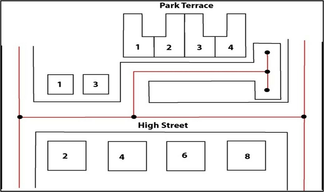
If a set of properties or a terrace are separated from the main carriageway and accessed by a metalled footway or highway the terrace must be recorded in the LSG as a type 1 or 2 Street. Show whether the terrace is publicly or privately maintainable in the ASD Record. For an example, see Figure 2.
Figure 2 - Type 1 or 2 Street Name (Park Terrace)
5.3.4.9
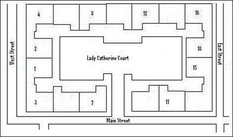
Figure 3 shows a courtyard which meets the following criteria:
- It is passable to vehicular traffic.
- It is metalled.
- It is enclosed.
5.3.4.10
These Streets, which can be courts, parades, plazas or precincts must be recorded as type 1 or 2 Streets in the LSG.
5.3.4.11
If a Street like this is not a Highway, the Authority Street Custodian must liaise with the SNN Officer and the Authority Address Custodian to reach agreement as to whether it must be recorded as a Street or not.
5.3.4.12
If a property has a private path, with no public access, within its curtilage to connect different parts of the property, that path is not a Street, for example, a path between blocks within a school site.
5.3.4.13
If a property has a courtyard or quadrangle which is accessed only through the building, that courtyard or quadrangle is not a Street, for example, a quadrangle within a University Hall of Residence.
5.3.4.14
A type 3 Street must not be changed to a type 2 Street. If a type 2 Street is recorded as a type 3 Street in error, then the Street must be closed and a new USRN allocated as a type 2 Street.
Figure 3 - Type 1 or 2 Street name (Courts)