10.1.3.1
Streets (other than type 2 Streets for Motorways) must be split at the external boundary of the Local Highway Authority administrative area. For further information about recording Motorways, see Section 7.
10.1.3.2
Streets within a Local Highway Authority must not be split at internal administrative boundaries, except at District Council administrative boundaries in a two-tier government structure. Streets must not be split at parish, wards or other internal administrative boundaries – these should be regarded as “soft” boundaries.
10.1.3.3
If a Street passes from one TOWN_NAME to another there must be separate Street Data for each TOWN_NAME. The separation must be at a point approximate to the boundary.
10.1.3.4
Typically, this means splitting the Street at a junction close to the boundary. The TOWN_NAME is normally that in which the major length of the Street is.
10.1.3.5
A location is described as a TOWN_NAME or as a combination of TOWN_NAME and LOCALITY. LOCALITY must be used only if it is necessary to distinguish between two Streets of the same name within the same town. Acceptable exceptions to this rule are identified below.
10.1.3.6
Punctuation must only be included within the TOWN_NAME and LOCALITY if the punctuation is part of the official TOWN_NAME and LOCALITY, for example “Stoke-on-Trent”. Ampersands must only be used as a replacement for the word “and” if it appears in the official version of the name of a town, locality or Street. Full stops or commas must not be used as part of any TOWN_NAME and LOCALITY.
10.1.3.7
The Attribute name TOWN_NAME can be misleading particularly in sparsely populated areas. It must be populated with one of the following geographical identifiers, where continuity of the TOWN_NAME can be achieved for the Street Name or Street Description:
- The name of a city.
- The name of a town.
- The name of a village.
- The name of a hamlet.
- The name of a parish.
- A recognised settlement name.
- A geographical identifier.
10.1.3.8
The TOWN_NAME therefore represents one of the above and not the post town allocated by Royal Mail, although they are often the same name.
10.1.3.9
A TOWN_NAME must always be recorded for a type 1 and a type 2 Street and may be recorded for a type 3 and a type 4 Street.
10.1.3.10
LOCALITY defines an area or geographical identifier within a town, village or hamlet that must be a recognised geographical name.
10.1.3.11
LOCALITY must only be used for Streets in the following scenarios:
- If there is more than one Street of the same name in the same town.
- If the inclusion of a locality is necessary in addition to TOWN_NAME to avoid ambiguity in the identification of that Street and there is evidence of a recognised geographical identifier.
- If a settlement, with its own settlement name in common use, is in the same parish as another settlement but is distinctly separate, particularly in sparsely populated areas.
- If a site contains named Streets and the site name is included in the Postal Address, for example airports, out of town shopping centres, industrial estates. This allows for Postal Addresses to be constructed which are meaningful to users.
- If the Street falls within a London Borough, apply the following rules. For a map of the London Boroughs, see Appendix C.
- For all Streets within Inner London Boroughs the TOWN_NAME must be recorded as ‘London’ and an appropriate locality must be added to each Street. This applies to:
- Camden.
- City of London.
- Hackney.
- Haringey.
- Hammersmith & Fulham.
- Islington.
- Kensington & Chelsea.
- Lambeth.
- Lewisham.
- Southwark.
- Tower Hamlets.
- Wandsworth.
- City of Westminster.
- For all Streets within Outer London Boroughs the appropriate local description for the town must be used, for example Wimbledon, Enfield, Harrow etc. and the Locality only used to avoid ambiguity within that ‘Town’.
- Outer London Boroughs must reach agreement as to how this Field is populated consistently across London Boroughs to avoid duplication. This applies to:
- Barking and Dagenham
- Barnet.
- Bexley.
- Brent.
- Bromley.
- Croydon.
- Ealing.
- Enfield.
- Greenwich.
- Harrow.
- Havering.
- Hillingdon.
- Hounslow.
- Kingston upon Thames.
- Merton.
- Newham.
- Redbridge.
- Richmond upon Thames.
- Sutton.
- Waltham Forest.
- For all Streets within Inner London Boroughs the TOWN_NAME must be recorded as ‘London’ and an appropriate locality must be added to each Street. This applies to:
10.1.3.12
Apply the following rules when creating localities:
- If LOCALITY is used, it must be a meaningful geographic identifier.
- LOCALITY must be a local area name and not a Street Name.
- If LOCALITY and TOWN_NAME are the same, then only the town name must be recorded.
- Post towns or postcodes or parts of postcodes must not be recorded in LOCALITY.
- LOCALITY must be agreed between the Authority Street Custodian and the Authority Address Custodian.
- The LOCALITY AND TOWN_NAME contained in the ASG must not be based on Postal Address locations and post towns as defined by the Royal Mail Address Management Unit (AMU). They are geographical identifiers which help identify a BLPU and an LPI through the commonly known description of the location.
- If Streets pass through several different identified geographic locations, each Street section, to avoid ambiguity, must be recorded as a separate Street with the appropriate geographic location.
- If there are no properties associated with Streets passing through several different locations that are recorded as single Streets, these must not be split until a change is required.
- Splits to such Streets must occur at clearly marked boundaries or landmarks to facilitate identification of different Street start and end points on the ground.
- Type 1 Streets and type 2 Streets must be split only if one of the following changes occurs along the length of the Street:
- The SNN Authority.
- The LOCALITY Field if is used to identify a local geographic boundary.
- The Street Name.
- The town name or locality name.
- Type 1 Streets must not be split to show change of maintenance responsibility.
- Type 2 Streets must be split only at a recognisable physical marker.
- Type 2 Streets must not be split at a geographic boundary.
10.1.3.13
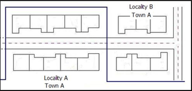
In Figure 25, a Street passes from Town A, through a locality and into another locality. Possibly, the LHA or the SNN Authority needs this Street to be split into as many as 3 USRNs. The Authority Street Custodian must consult with the Authority Address Custodian in the SNN Authority before a Street like this is split.
10.1.3.14
Splits must not be based solely on ward or parish boundaries. Local boundaries such as ward or parish boundaries change frequently over time, basing a network on these soft boundaries requires considerable amount of network maintenance work.
Figure 25 - Crossing locality and town boundaries
10.1.3.15
When a Street is split, possibly the boundary of the town or village is not represented in any mapping material or clearly visible on the ground. Also, the split often occurs between junctions. Therefore, be careful to split ESUs at appropriate places where the Street meets or passes an identifiable geographic feature in the real world. Some examples are:
- Rivers.
- Bridges.
- Junctions.
- Footpaths with a PRoW designation or other Footpaths.
10.1.3.16
All Streets must split the USRN at town and/or locality boundaries.
10.1.3.17
Each USRN must inherit the town and/or locality the USRN resides in.
10.1.3.18
LOCALITY must not be used as standard and must instead only be used when fitting the criteria described in Section 10.1.3.5.
10.1.3.19
It is not a requirement to split a Street where no addresses are affected, or where the addition of a locality provides no further clarity on the location of the USRN.
10.1.3.20
When new Records are created, the SNN Officer must work closely with the Authority Street Custodian through the Authority Address Custodian to ensure all parties agree town and/or locality descriptions.
10.1.3.21
ADMINISTRATIVE_AREA_NAME is mandatory. It must be the official current name of the LHA, excluding such words as: ‘Council’, ‘Borough’, ‘District’. Permitted values include the following:
- Unitary Council name.
- English Shire County name.
- London Borough name.
- Metropolitan Borough name.
- Welsh Unitary Council name.
10.1.3.22
For a list of Local Highway Authorities, see Appendix B.
10.1.3.23
If TOWN_NAME is used, sometimes it is the same as ADMINISTRATIVE_AREA_NAME, for example, TOWN_NAME: Gateshead, ADMINISTRATIVE_AREA_NAME: Gateshead
10.1.3.24
The following must not be recorded in ADMINISTRATIVE_AREA_NAME:
- Highways England.
- Transport for London.
- Postal County Name (if different from ADMINISTRATIVE_AREA_NAME).
- Historical County Name.